
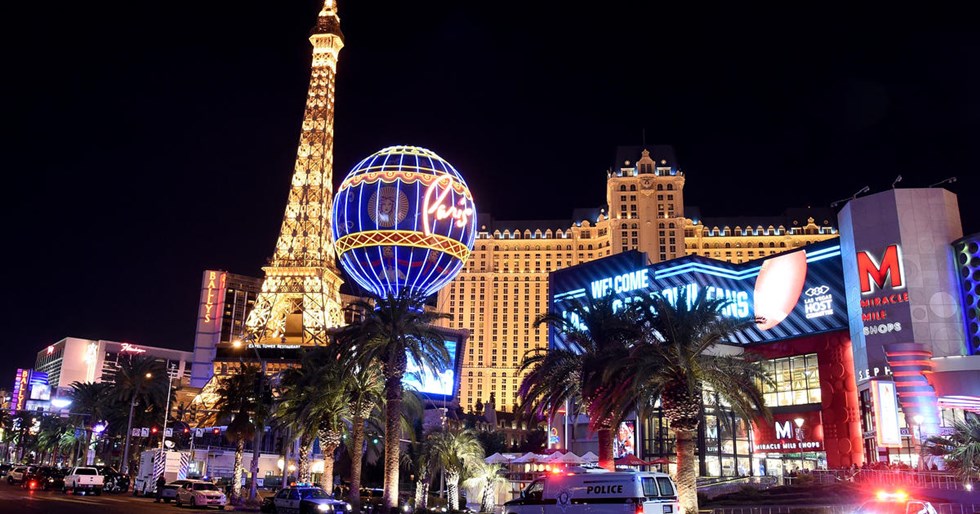
Today we will start from San Francisco, travel through California and Nevada, and arrive at the world's casino city, Las Vegas.
Itinerary:
San Francisco → Las Vegas → Las Vegas Night View Tour (at your own expense)
Las Vegas Night Tour(AG) Las Vegas Night Tour
When night falls and the lanterns come on, the casino is a sea of neon lights, a colorful world of light and shadow. The electricity consumption of the five-kilometer-long Las Vegas Strip in one night can power a city of 500,000 people for a year. The architecture here integrates the essence of the world. It is a well-deserved miracle of ergonomics and the most American city!
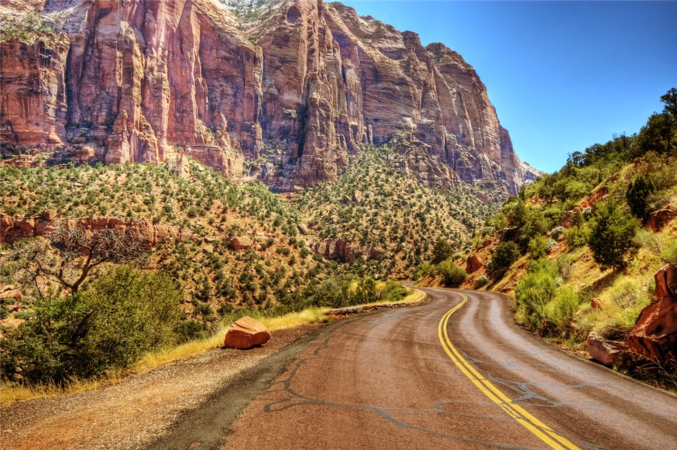
Today we will experience what the ever-changing American West is. The first stop was Zion National Park. Zion National Park is a beautiful place with its tranquil beauty of mountains and clear waters. After that, we went to Bryce Canyon National Park. Bryce is not so much a canyon, but more like a huge open-air arena. The towering brown stone layers are stacked like stone figurines guarding the heaven and earth. Overnight in Blythe.
Itinerary:
Las Vegas → Zion National Park (mandatory item, 45 minutes) → Checkerboard Mountain Wall Group (25 minutes) → Bryce Canyon National Park (mandatory item, 60 minutes) → Bryce
Zion National Park Zion National Park
Zion National Park is a dream destination for hikers and photographers. Although it is located in the desert, the terrain is anything but barren. Formed by millions of years of erosion, the park's diverse rock formations, countless wilderness trails and one-of-a-kind wildlife beckon to those seeking an experience of solitude and inspiration. The park's many canyons, fauna and cultural sites are suitable for exploration in any season, but spring and autumn are at their most pleasant and the flowers are in full bloom.
Bryce Canyon National Park Bryce Canyon National Park
Bryce Canyon National Park is located in southwestern Utah, USA. Although its name contains the word canyon, it is not a real canyon, but a huge natural amphitheater formed by erosion along the east side of the Ponsagunt Plateau. Its unique geographical formations, called lithosphere, are formed by wind, water and ice erosion from rivers, and sedimentary rocks from lake beds. The red, orange and white rocks within it form a unique natural landscape, so it is known as the palace of natural stone figurines.
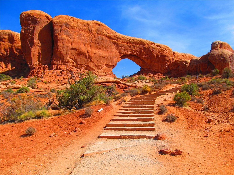
Today we will set off to visit Canyonlands National Park. This place is like an island suspended in the sky, and the scenery is extremely spectacular! After reluctantly leaving Canyonlands National Park, we will head to Arches National Park. As the largest concentration of natural sand and stone arches in the world, Arches National Park covers an area of approximately 309 square kilometers and has more than 2,000 natural rock arches. The archstones you can see today have resisted the erosion of wind and rain for thousands of years in various strange ways, and they still stand proudly on this salt layer, which is breathtaking.
Itinerary:
Canyonlands National Park (mandatory, 60 minutes) → Arches National Park (mandatory, 120 minutes)
Canyonlands National Park Canyonlands National Park
Canyonlands National Park is located at the confluence of the Green River and the Colorado River in southeastern Utah. It is a collection of sandstone towers and canyons formed by years of river erosion and erosion by wind, frost, rain, and snow. It has become one of the most famous erosion areas in the world and is famous for its dangerous peaks and rugged rocks. Island in the Sky is perched on a steep sandstone cliff, rising 1,000 feet above the surrounding terrain. Each overlook offers spectacular views of the canyon area from a different angle.
Arches National Park Arches National Park
Arches National Park is located in Utah, USA, near the town of Moab, covering an area of 309 square kilometers and preserving more than 2,000 natural rock arches. About 300 million years ago, this salt formation was an ocean. Millions of years after the sea disappeared, the salt layers were covered by dregs from the air and water, and extruded into rocks with other debris. After the uplift of the earth's crust and natural weathering, it became the arch it is today. There are not only arches in the park, but also numerous unique geological features such as large and small spiers, pedestals, and balancing stones; all the stones have textures with very strong color contrasts.
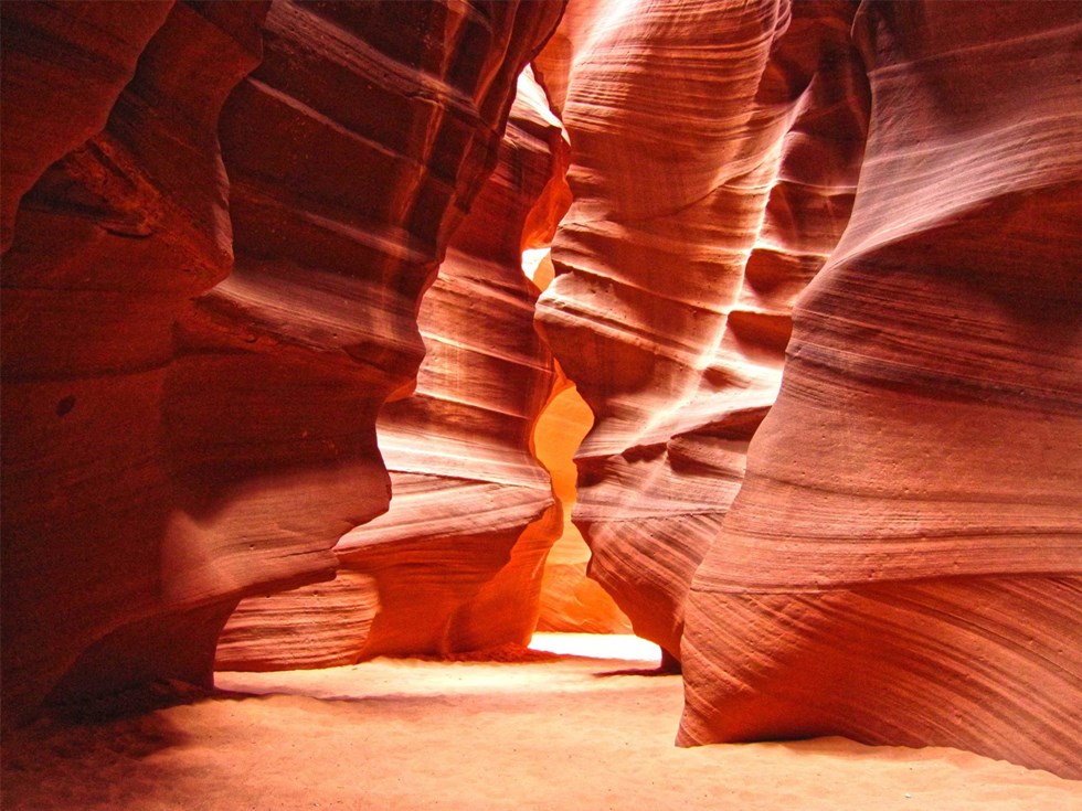
Friends who have the plot of a western blockbuster are in luck, today we will come to Monument Valley. Monument Valley frequently appears in movie scenes and is a symbol of the original Great West of the United States. The cross-country long-distance race in "Forrest Gump" ended here. Then go to Horseshoe Bay, a famous photography spot selected by American Geographic Magazine. The river turns 360 degrees in the red-brown canyon, cutting out a horseshoe-shaped canyon. Horseshoe Bay is named after it. Finally, we went to visit the peculiar slit cave and Lower Antelope Canyon, one of the top ten photography locations in the world. The rock walls of the Cacao Cave are eroded by wind and torrents over thousands of years, forming a perfect wave shape, which is an abstract painting of nature. Cave Cave has always been a pure place for Navajo Indians to sit and meditate. They believe that they can listen to the voice of God here. Overnight at Tuba Indian Reservation.
Itinerary:
Monument Valley (mandatory item, 120 minutes, you can take a jeep tour at your own expense) → Horseshoe Bend (mandatory item, 75 minutes) → Lower Antelope Canyon (own expense, 120 minutes)
Monument Valley Monument Valley
Monument Valley began to appear in many media in the 1930s as a symbol of the original Great West of the United States. The most famous one is in many western films by American director John Ford, including "Stagecoach" and "The Searchers". The cross-country run in director Robert Chamakis's "Forrest Gump" ends here. The magnificence of Monument Valley is difficult to describe in words. Huge sculptures stand on the red field. This is the resonance of desolation and wild music, a holy place for the sublimation of life and soul.
Horseshoe Bend Horseshoe Bend
Horseshoe Bend – one of the top 10 best photography locations in the United States by National Geographic! The dense aquatic plants on the Colorado River bed make the river water appear fluorescent green in the sunlight. The river turns 360 degrees in the reddish-brown canyon, cutting a horseshoe-shaped canyon, hence the name Horseshoe Bend. Standing on the edge of the cliff, you will be immersed in the breathtaking beauty of the clear water, blue sky and red rocks.
Lower Antelope Canyon Lower Antelope Canyon
Lower Antelope Canyon is located in northern Arizona, USA. It was formed from soft sandstone after millions of years of various erosion forces. Flash floods often flow into the canyon during the monsoon season. Due to the sudden increase in rainfall, the flow rate of the flash flood is quite fast. In addition, the narrow channel narrows the river channel, so the vertical erosion force becomes relatively larger, forming a corridor at the bottom of Lower Antelope Canyon and a hard and smooth edge like flowing water on the canyon wall. There is no artificial lighting in Lower Antelope Canyon. All visible light comes from the cracks at the top of the canyon. The light is repeatedly refracted by the rock texture and enters the valley bottom, producing dreamlike irregular color changes. These colors range from deep to light, colorful and beautiful.
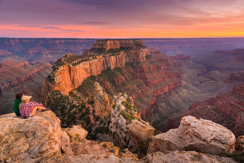
In the early morning we drove to the Grand Canyon National Park, known as the first of the seven natural wonders of the world, to appreciate the magic of the Creator. Here, every passerby is a photographer, and every photo is a landscape painting. You can take a helicopter or sightseeing plane at your own expense to overlook the Grand Canyon from the air. Leaving the Grand Canyon Park, we will drive through the famous Hoover Dam, and then go to Emerald Bay, a miraculous natural landscape on the border of the Colorado River. This is a paradise for kayakers. Not only can you enjoy the clear lake water that looks like green jelly, but you can also experience the fun of canyon exploration here. Finally arrive at the gambling and entertainment capital of the world - Las Vegas! In the evening, you can take a night tour with an experienced driver and guide at your own expense, or enjoy the world's highest level singing, dancing and magic show!
Itinerary:
Grand Canyon National Park East Rim & South Rim (mandatory, 4 hours, you can take a helicopter or small plane at your own expense) → Hoover Dam (passing) → Colorado River Emerald Bay Kayak + Beach Cruise (at your own expense, 1.5-2 hours) → Las Vegas
Grand Canyon National Park Grand Canyon National Park
Grand Canyon National Park is located in northern Arizona, covering an area of 1,904 square miles and was established in 1919. The Grand Canyon was approved to be included in the UNESCO World Heritage List as a natural heritage in 1979. Grand Canyon National Park is one of the Seven Wonders of the World, formed by the Colorado River cutting through the plateau. It is one of the most worth-seeing national parks in the United States.
Grand Canyon South Rim
The South Canyon, also known as the South Rim of the Grand Canyon, is located in the middle of the Grand Canyon. The terrain is steep and majestic, the canyon is bottomless and the largest in scale. The park is mature and complete, especially suitable for self-driving on the road. It does not have any commercial facilities, and almost every viewing spot has been preserved as much as possible. The large-scale magnificent landscape of the South Canyon and the perfect and suitable playing environment make people feel filled with emotion and linger over the miraculous craftsmanship of the Creator.
Emerald Cove Kayaking + Beach Cruise on the Colorado River
After arriving at the Willow Beach pier, a professional water instructor will explain to you about kayaking, and then start kayaking on the Colorado River (maximum 2 people per kayak) - transparent bottom kayaks are specially arranged so that you can enjoy the green aquatic plants and fish in the river anytime and anywhere. After rowing for about half an hour (one way), you will reach the beach. You can go ashore to admire the historical relics of the Hoover Dam when it was built, as well as the beautiful scenery of the canyon and river, take photos and repair, and then row back to the dock. The paddling distance is moderate, and the instructor will accompany you throughout the entire journey. It is suitable for all ages, and the experience is excellent. Full marks online!
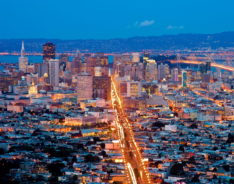
Returning to San Francisco from Las Vegas with a happy mood.
Itinerary:
Las Vegas → San Francisco
Seat selection and payment instructions
1. Applicable seating range
"Preferred seats" usually refer to the front row area in the bus compartment (specifically based on the actual seat distribution on the bus that day). These seats enjoy a wider field of view, a more convenient boarding and alighting experience, and a relatively comfortable riding space.
2.Charging standards
(1) Itinerary of 8 days or less: USD 12/person/day
(2) Itinerary of more than 8 days: USD 15/person/day
The fee will be calculated on a daily basis based on the total number of days of the trip and will be charged once upon registration.
3. Reservation rules
(1) Voluntary choice: All tour participants can voluntarily choose whether to purchase preferred seat services when registering based on their own needs.
(2) First-come-first-served: The number of preferred seats is limited. Usually for models with 15 seats or above, the first three rows belong to the paid area. Confirmation is based on payment order, while stocks last.
(3) Priority for traveling together: If traveling companions (same order) need to book preferred seats at the same time, we will try our best to arrange adjacent seats.
4. Precautions
(1) The preferred seat fee does not include any other service content, but only the priority of seat location.
(2) If the car needs to be replaced due to weather, road conditions, vehicle scheduling, etc., we will try our best to provide a seat arrangement of equal value or refund the corresponding fee based on the actual number of days affected.
(3) For passengers who have not purchased this service, we will allocate other seats for free in rotation order, and try to ensure that the seats of traveling companions are adjacent to each other.
5.Refund policy
(1) If the order is canceled more than 7 days before the start of the trip, the preferred seat fee will be fully refunded;
(2) If canceled 3-7 days before the trip, 50% of the fee will be refunded;
(3) If canceled within 3 days before the trip, no refund will be given.
Itinerary instructions
Special instructions:
1. The above itinerary sequence, attractions, flights and accommodation locations may be temporarily changed, modified or replaced. The final itinerary is subject to the itinerary confirmed by our company before departure;
2. Our company reserves the right to change the itinerary and add price differences due to factors such as airlines, visas, governments, weather, etc.;
3. The flight numbers and times listed in the itinerary are for reference only, and reasonable adjustments will be made based on the actual situation;
Travel information
1. Gathering and boarding requirements
(1) All tour group members must gather on time and depart on time. Please arrive at the pick-up location 15 minutes in advance. Our company's tour bus will not wait. If you fail to gather and set off at the agreed time and location, or fail to join midway, you will be deemed to have given up automatically and the fee will not be refunded.
(2) The pick-up and drop-off times stated in the tour notice are all estimated times, and the specific pick-up and drop-off locations are subject to confirmation by the company. If due to traffic conditions or other special circumstances, our company's bus cannot arrive at the boarding location on time or the time is temporarily changed, our company will notify you in time, so please be patient.
2. Vehicle and luggage requirements
(1) Passenger buses are divided into three types: buses, minibuses and minibuses. Generally, buses have luggage compartments dedicated to storing luggage, while minibuses and minibuses have relatively smaller spaces for luggage storage. In view of the limited space in the luggage compartment of the bus, it is recommended not to carry too much luggage when traveling. Our company will arrange vehicles according to the final group size, ensuring one person per person.
(2) In order to avoid overcrowding in front of the scenic spots, the bus parking areas in most cities are far away from the scenic spots, and drivers are not allowed to park casually. Violators will be subject to heavy fines. If necessary, the pick-up and drop-off location may be some distance away from the attraction. Please understand.
3. Safety tips for taking a bus
(1) Smoking in the car is prohibited.
(2) Please do not bring prohibited items.
(3) Do not fiddle with anything on the car at will to avoid unnecessary damage.
(4) During the temporary stop of the bus, obey the tour guide’s arrangements and do not stay away from the group.
(5) When group members get off the bus for sightseeing, dining, or shopping, please close the windows of the tour vehicle and carry your valuables with you. The travel agency is not responsible for any loss or theft.
(6) Due to the long journey time and heavy vehicle loads, if the car breaks down and affects the itinerary, the travel agency will quickly take remedial measures and ask the group members to actively cooperate.


